←Select platform
LeadFillMode Enumeration
Summary
Specifies how a polygonal shape with crossing lines is filled.
Syntax
C#
Objective-C
C++/CLI
Java
Python
public enum LeadFillMode typedef NS_ENUM(NSInteger, LTLeadFillMode) {LTLeadFillModeAlternate,LTLeadFillModeWinding};
public final class LeadFillModeextends java.lang.Enum<LeadFillMode>
public enum class LeadFillMode class LeadFillMode(Enum):Alternate = 0Winding = 1
Members
| Value | Member | Description |
|---|---|---|
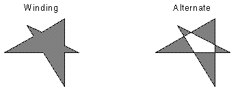
| 0 | Alternate | The filled area includes the area between odd-numbered and even-numbered polygon sides on each scan line. |
| 1 | Winding | All pixels that are inside the resulting exterior lines are filled. |
Remarks
The following figure describes how fill mode is used:

Example
C#
Java
using Leadtools;using Leadtools.Codecs;using Leadtools.ImageProcessing;using Leadtools.ImageProcessing.Core;using Leadtools.ImageProcessing.Color;using Leadtools.Dicom;using Leadtools.Drawing;using Leadtools.Controls;using Leadtools.Svg;public void AddPolygonToRegionExample(){RasterCodecs codecs = new RasterCodecs();string srcFileName = Path.Combine(LEAD_VARS.ImagesDir, "Image1.cmp");string destFileName = Path.Combine(LEAD_VARS.ImagesDir, "Image1_AddPolygonToRegion.bmp");// Load the imageRasterImage image = codecs.Load(srcFileName);// Add a polygon regionRasterRegionXForm xform = new RasterRegionXForm();xform.ViewPerspective = RasterViewPerspective.TopLeft;xform.XOffset = 0;xform.YOffset = 0;xform.XScalarDenominator = 1;xform.XScalarNumerator = 1;xform.YScalarDenominator = 1;xform.YScalarNumerator = 1;int x1 = image.ImageWidth / 4;int y1 = image.ImageHeight / 4;int x2 = image.ImageWidth / 3;int y2 = image.ImageHeight / 3;LeadPoint[] pts ={new LeadPoint(x1, y1),new LeadPoint(x2, y1),new LeadPoint(x1, y2),new LeadPoint(x2, y2)};image.AddPolygonToRegion(xform, pts, LeadFillMode.Winding, RasterRegionCombineMode.Set);// Draw something on the imageInvertCommand command = new InvertCommand();command.Run(image);// Save the imagecodecs.Save(image, destFileName, RasterImageFormat.Bmp, 24);image.Dispose();codecs.Dispose();}static class LEAD_VARS{public const string ImagesDir = @"C:\LEADTOOLS23\Resources\Images";}
import java.io.File;import java.io.FileInputStream;import java.io.IOException;import java.io.InputStream;import java.util.ArrayList;import java.util.List;import org.junit.*;import org.junit.runner.JUnitCore;import org.junit.runner.Result;import org.junit.runner.notification.Failure;import static org.junit.Assert.*;import leadtools.*;import leadtools.codecs.*;import leadtools.imageprocessing.core.*;import leadtools.svg.*;import leadtools.imageprocessing.CloneCommand;import leadtools.imageprocessing.FillCommand;import leadtools.imageprocessing.FlipCommand;import leadtools.imageprocessing.GrayscaleCommand;import leadtools.imageprocessing.color.InvertCommand;import leadtools.imageprocessing.color.PosterizeCommand;public void addPolygonToRegionExample() {final String LEAD_VARS_IMAGES_DIR = "C:\\LEADTOOLS23\\Resources\\Images";RasterCodecs codecs = new RasterCodecs();String srcFileName = combine(LEAD_VARS_IMAGES_DIR, "Image1.cmp");String destFileName = combine(LEAD_VARS_IMAGES_DIR, "Image1_AddPolygonToRegion.bmp");// Load the imageRasterImage image = codecs.load(srcFileName);// Add a polygon regionRasterRegionXForm xform = new RasterRegionXForm();xform.setRasterViewPerspective(RasterViewPerspective.TOP_LEFT);xform.setXOffset(0);xform.setYOffset(0);xform.setXScalarDenominator(1);xform.setXScalarNumerator(1);xform.setYScalarDenominator(1);xform.setYScalarNumerator(1);int x1 = image.getImageWidth() / 4;int y1 = image.getImageHeight() / 4;int x2 = image.getImageWidth() / 3;int y2 = image.getImageHeight() / 3;LeadPoint[] pts = { new LeadPoint(x1, y1), new LeadPoint(x2, y1), new LeadPoint(x1, y2), new LeadPoint(x2, y2) };image.addPolygonToRegion(xform, pts, LeadFillMode.WINDING, RasterRegionCombineMode.SET);// Draw something on the imageInvertCommand command = new InvertCommand();command.run(image);// Save itcodecs.save(image, destFileName, RasterImageFormat.BMP, 24);// Clean upimage.dispose();codecs.dispose();assertTrue("file unsuccessfully saved to " + destFileName, (new File(destFileName)).exists());System.out.printf("File saved successfully to %s%n", destFileName);}
Requirements
Help Version 23.0.2024.5.22
Products | Support | Contact Us | Intellectual Property Notices © 1991-2024 LEAD Technologies, Inc. All Rights Reserved.
Leadtools Assembly
